
In geography, erosion is the natural geological process that wears down materials and transports them through water, wind, and ice. It's an essential part of how the Earth is shaped, and abrasion is one of the most crucial types of erosion.
Abrasion is when particles like sand, pebbles, or rocks scrape, grind, and polish the surfaces they encounter, from coastal cliffs battered by waves to riverbeds carved by flowing water. Abrasion drives landform formation across various environments.


What is Abrasion?
Abrasion in geography is a type of erosion where materials like sand, pebbles, and rocks carried by natural forces such as water, wind, or ice wear down Earth’s surfaces through repeated friction. It plays a key role in shaping landforms like cliffs, valleys, and glacial landscapes.
This process occurs across many environments: waves battering coastlines, rivers dragging sediment along their beds, wind blasting sand in arid deserts, and glaciers grinding rocks over landscapes. In all cases, the transported material acts like natural sandpaper, smoothing, scraping, and reshaping the land over time.
Abrasion in geography is a key mechanism contributing to the erosion of coastal features over time; this process is most intense between the high and low tide lines and is especially effective during strong storm conditions. Abrasion can occur in four different ways and at different scales in Geography.

The intensity of abrasion depends on several factors: the hardness, velocity, mass, and concentration of the transported materials, as well as the resistance of the surface they strike.
Abrasion is irreversible, and there is only so much we can do to protect the shores, beaches, rocks and other landscapes. Because it reshapes landscapes and contributes to the formation of major landforms, abrasion is a key process studied in geomorphology and physical geography.
Types of Abrasion in Different Environments
Abrasion plays a key role in different natural environments. While the basic process of particles rubbing or striking against surfaces is similar, the agents (water, wind, ice, etc.) and the resulting landforms are different. There are four main types of abrasion in geography:
Fluvial Abrasion
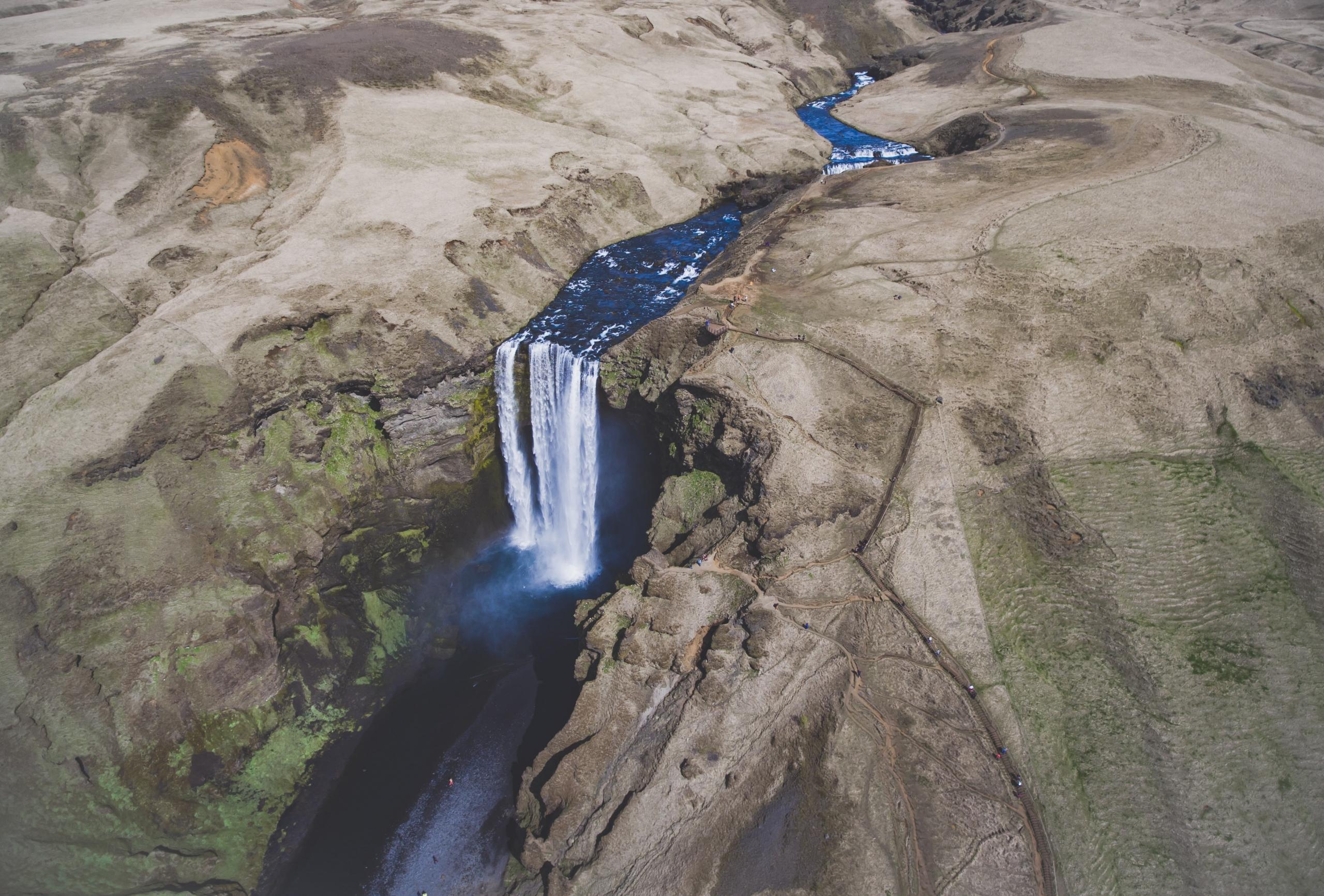
Fluvial abrasion takes place in rivers and streams. When water transports sediments like gravel, sand, and silt, these particles collide with the riverbank and banks, gradually wearing them down. This erosion process is more intense in faster-flowing sections of rivers, particularly during flooding.
Over time, fluvial abrasion deepens and widens river channels and can create distinctive features like potholes, gorges, and meanders. Fluvial abrasion helps us understand how landscapes evolve and how sediment is transported downstream, contributing to broader geomorphological change.
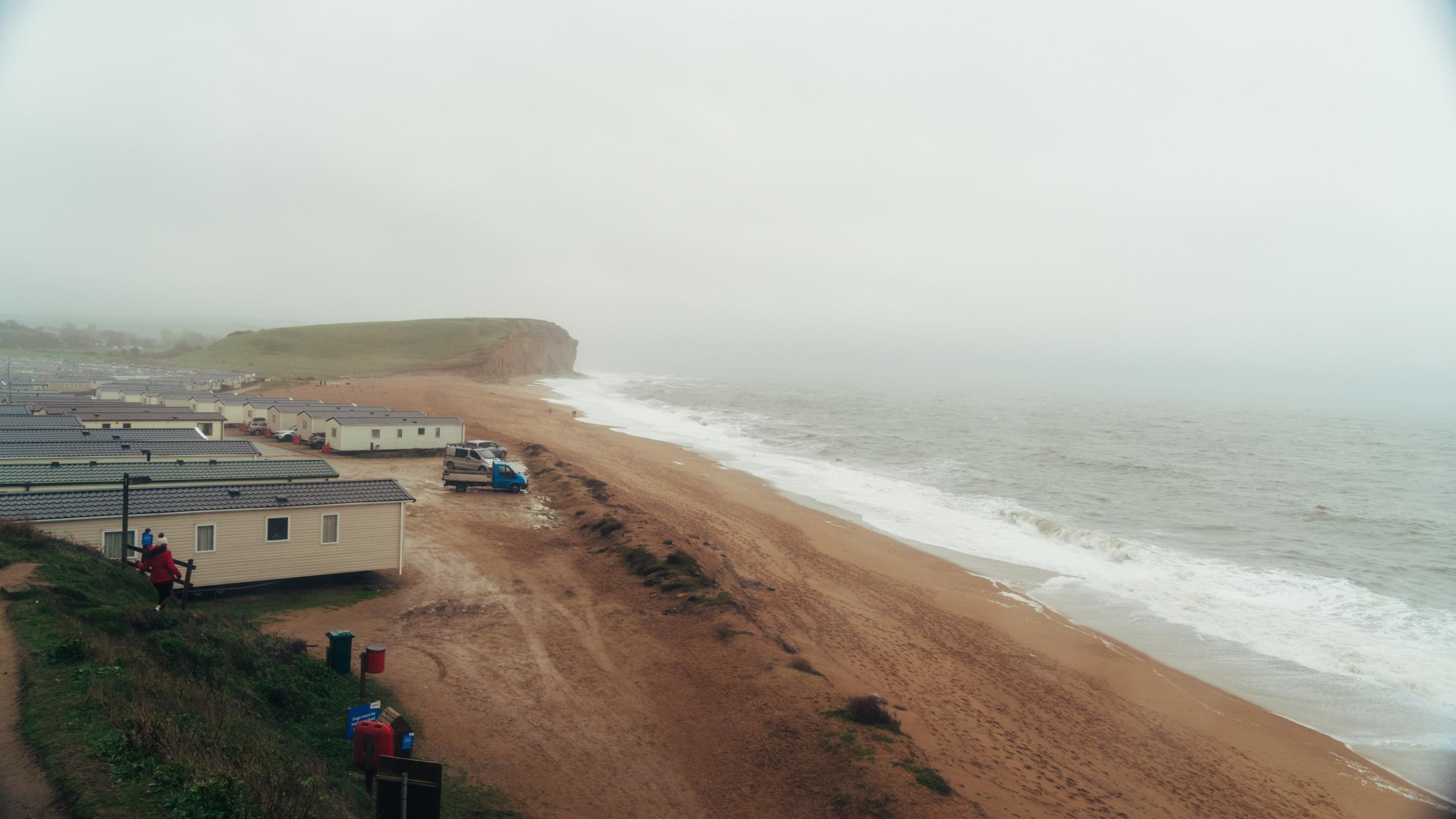
Coastal Abrasion
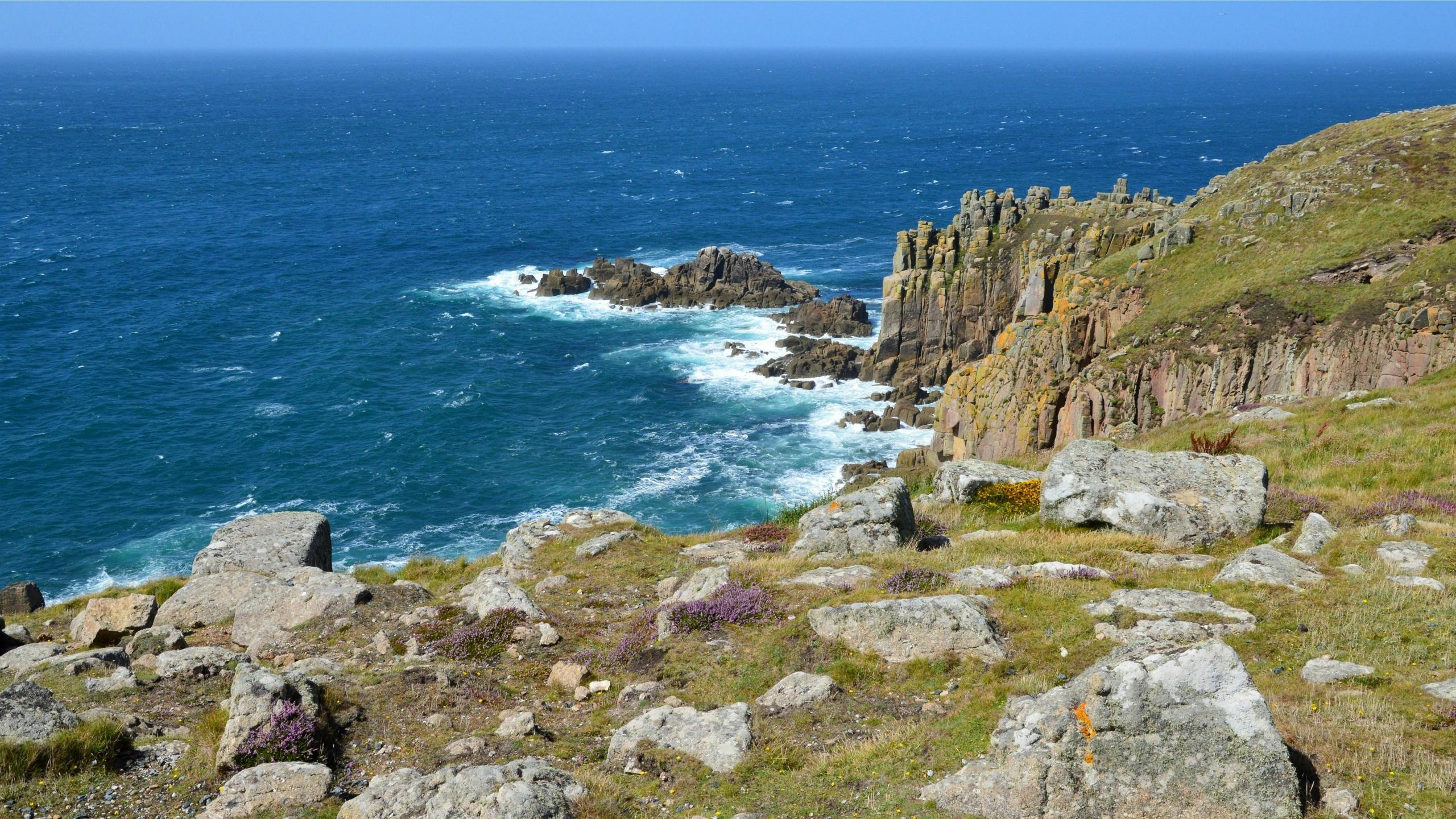
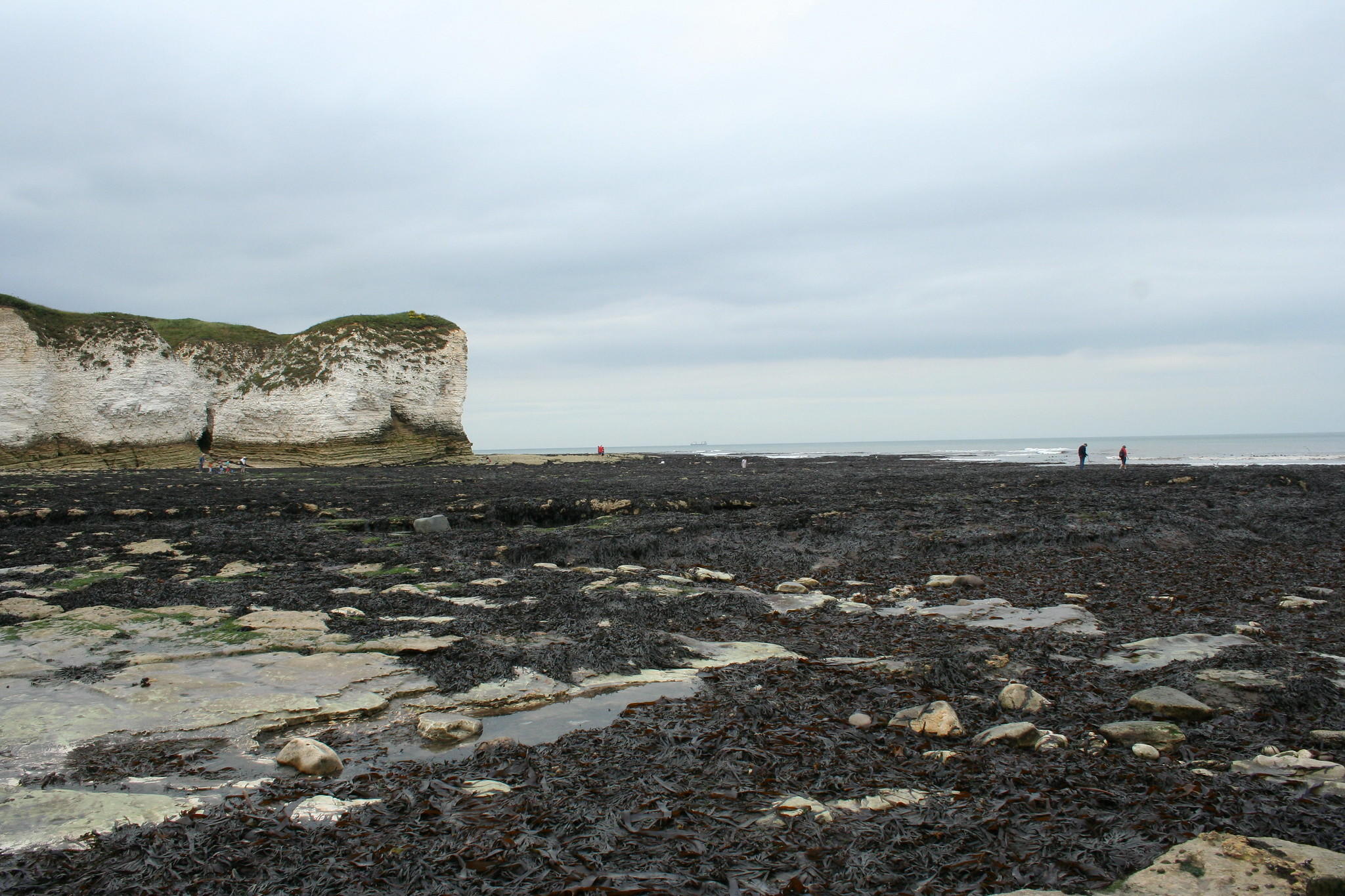
Coastal abrasion, as you can imagine, takes place along the coast. This is caused by waves crashing into the coast, carrying sand, pebbles, and even larger rocks. These materials are flung against cliffs and rocky coastlines, chipping away at the rock, contributing to broader coastal erosion.
This type of abrasion occurs most between high and low tide lines, with greater effects during storms and rough sea conditions. This leads to landforms like wave-cut platforms, sea caves, arches, and stacks.
Coastal abrasion, sometimes called corrosion, shapes cliffed coastlines and retreating shorelines. It can lead to issues like sea level rise, requiring coastal management.
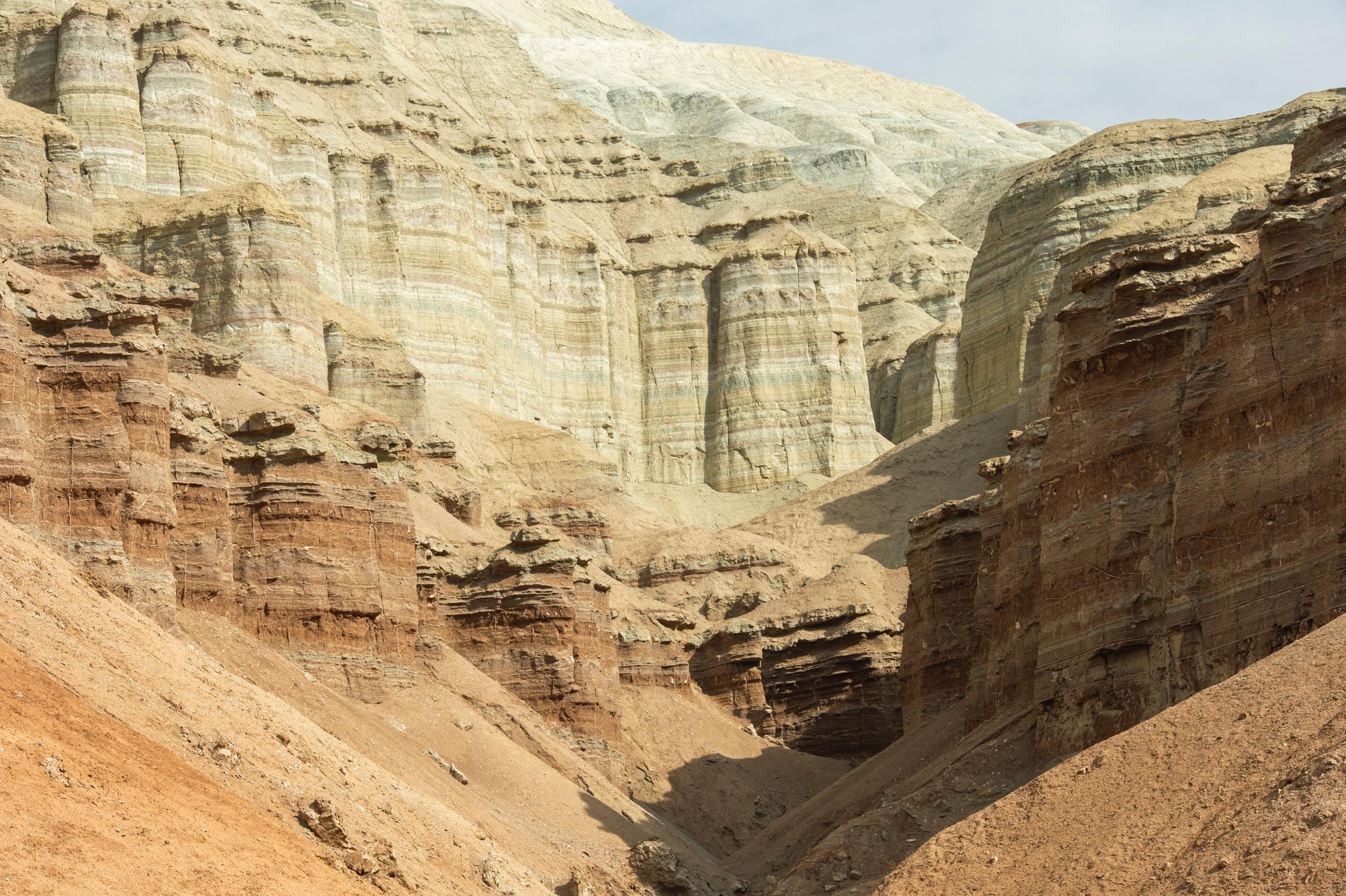
Glacial Abrasion
Glacial abrasion happens in colder climates when glaciers move slowly across the land. They drag embedded rocks and debris along their base, and these materials scrape against the underlying bedrock. The result is a smooth, polished surface and distinctive glacial landforms like striations (parallel scratches), U-shaped valleys, and rock basins.
The harder the debris, the greater the pressure and movement of the ice. Glacial abrasion shapes mountain and polar landscapes and contributes to sediment production and reshapes entire valley systems.
Aeolian Abrasion (Wind)
In arid and semi-arid environments, strong winds carry fine particles like sand and dust. These strike rock surfaces, gradually wearing them down. This abrasion occurs more in areas with minimal vegetation and abundant loose sediment, like deserts and dry lake beds.
Over time, aeolian abrasion can form landforms like ventifacts (rocks shaped by wind-blown sand) and yardangs (elongated ridges carved into soft rock). Wind abrasion tends to occur more slowly than water or ice, but it plays a significant role in desert geomorphology. Beyond our planet, you can find examples of aeolian abrasion on Mars.
Factors Influencing Abrasion
Abrasion doesn't occur with the same intensity in different areas. There are a number of key factors that will dictate the speed and degree at which it occurs.
Significance of Abrasion in Landscape Formation
Abrasion is a powerful force. It actively shapes the Earth's surface over time, but where does abrasion occur? Here's exactly how it contributes to the natural world around us.
Where Can You Observe Abrasion in the UK?
Abrasion and coastline erosion affect different parts of the world, and the United Kingdom is no exception. The vulnerability of its vast coastline is indicated by the fact that 23000 km is artificially protected.
Annual damages due to coastal erosion and the sea level increase are expected to increase with the acceleration of climate change and global warming, costing up to £126 million per year by 2080.
Examples of damages on the coastline in the UK:
Km of Coastlines cover the UK
Among the places that are most at risk of coastal erosion due to factors such as weather changes that affect the waves are Kessingland in Suffolk, Hornsea in East Yorkshire, and Withernsea in East Yorkshire, to name a few. These locations have been experiencing drastic erosion effects and changes that have destroyed the beach and cliffs, but also affected the lives of people living in these zones.
Erosion processes are a significant indicator of the health of a specific environment and of the Earth in general. Seeing the erosion process accelerating is an indicator of the pressure that human activity represents for our planet and environment.
So, where does abrasion fit into the study of geography? Abrasion geography and the processes of erosion generally fall under the branch of physical geography.
More coastal erosion in the UK
Physical geography
Physical geography is defined as the study of the processes that shape the Earth’s surface, such as the animals, the plants that inhabit it and the spatial patterns they exhibit.
Since the mid-to-late 1800s, physical geographers and, in particular, geomorphologists dominated the discipline of geography until the late 1930s.
The change in the discipline occurred after the emphasis on the description and classification of climates, biomes, landforms, and an excessive dose of environmental determinism brought physical geography to its lowest point in the 1950s.
A change in the discipline was much needed, and this happened between the 1950s and 1960s, when physical geography and human geography, as well, underwent a radical quantification period.
During this time, physical geography was defined as the branch of geography that encompasses the natural sciences and deals with the processes and patterns in the natural environment.
This was followed by a period of intense disciplinary specialisation in the 1970s, resulting in the recognition of five broad divisions of physical geography:
- Geomorphology
- Climatology
- Biogeography
- Soil science
- Quaternary environmental change
Abrasion, a GCSE and A-Level topic
Physical geography is one of the main topics that is evaluated for the GCSE geography subject. Thus, having a good grasp of physical geography is not only essential to achieving good grades, but it is also important to understand our natural world, the environment and how we relate to it.
Each aspect of the physical geography section aims to lay out the foundation of what geography is, what it measures and observes, which tools it needs to gather this information, and through which methods and maps or surveys it will display this analysed information.
Abrasion and erosion processes are just one of the numerous subjects students have to learn to achieve their GCSE successfully. Furthermore, during the A-Level programme, Physical Geography is among the main topics covering the integral geography subject. Having the GCSE foundation is the best to pursue the A-Level geography.
Which Geography Topics Do You Need to Learn to Pass the GCSE in Geography Successfully?
The geography curriculum can be intimidating for students; however, you can always get yourself organised with your classmates and create study groups. If this is not the way you like to prepare for an exam, you can also rely on a Superprof Tutor who can help you achieve your study goals and study thoroughly the various subjects of the curriculum.
For any revision, consider that what will lead to success in the GCSE Geography exam includes:
Another important resource for preparing for your GCSE Geography exam is past papers. These will allow you to practice, gain experience, and fully understand how the exam is structured and what is expected of you to achieve the grade you need or want for your future applications.
Here are some potential questions from the GCSE Geography exam where erosion might be covered:
Learn to draw diagrams for the exam
If you want to study the erosion process or coastal abrasion, past papers including this specific subject are available to revise.
This also means that erosion is a significant topic because it takes into account different geographical and environmental areas affected by abrasion, through wind, rocks, destructive waves, and glaciers. Thus, it demands a wide knowledge of the physical geography subject and its subdisciplines.
Knowing different erosion processes and being able to explain and recognise each of the four abrasion processes:
- hydraulic action
- glacial abrasion
- aerial processes
- channel transport
It is a requirement for your GCSE geography examination, A-Level geography qualification, but mostly for your understanding of the natural environment and how human activity is part of these effects.

In addition, the UK is a beautiful country where you can wander and apply the skills you have learned during your geography studies and degrees, you will also have the possibility to broaden your understanding of the environment and society.
As you can see, geography encompasses a wide range of topics, including abrasion and coastal erosion, which are just one of many fields of research and application. This diversity means that studying geography and acquiring the necessary skills can lead to numerous career opportunities. Among the skill sets that you will acquire are:
- Cartographic skills
- Graphical skills
- Statistical skills
- Information and Communications Technology (ICT) skills
This set of skills will allow you to read diagrams that are dedicated to abrasion in geography, commonly called abrasion geography diagrams, and determine the different levels of abrasion and how it affects the environment or the geography of a specific environment.
If you have a passion for the environment or human activity and feel committed to building a world where nature and humans coexist in a balanced way, Geography might be a good option for you!
Erosion Defined
Erosion is a natural phenomenon where the wearing away and subsequent transportation of various materials, such as rocks, by the action of water, wind, and ice shapes the land. It is caused by friction or rubbing between one element and another.
Factors such as climate, topography, and vegetation influence erosion, and it can be exacerbated by human activities or, more recently, by climate change.
Different mechanical or chemical detachment and alteration processes occur during erosion, including abrasion.
Abrasion is one of the processes involved in erosion.
Weathering is often confused with erosion, as they are related. However, in weathering, rocks are merely broken down by natural processes (such as weather, plants, animals, and chemical reactions), whereas in erosion, the rocks are transported and reshape other landforms.
The Four Types of Erosion
Four different kinds of erosion are defined in geography:
| Erosion Process | Description | Primary Effects |
|---|---|---|
| Hydraulic Action | Hydraulic action refers to the sheer power of waves as they forcefully collide with cliffs. The impact forces air into the cracks in the rock, leading to the fragmentation and disintegration of the cliff. | This process can result in the creation of sea caves, arches, and stacks. |
| Abrasion | Abrasion occurs when pebbles grind along a rock platform, similar to the action of sandpaper. Over time, this process results in the development of a smoother surface on the rock. | Abrasion contributes to the formation of features such as wave-cut platforms and rocky shorelines. |
| Attrition | Attrition takes place when rocks carried by the sea collide with each other, causing them to break into smaller and more rounded fragments. This process contributes to the formation of smaller, rounded rocks. | Formation of smaller, rounded rocks, known as shingle beaches. |
| Solution | Solution is the erosion process where seawater dissolves certain types of rocks. In the UK, chalk and limestone cliffs are particularly prone to this type of erosion, leading to the gradual dissolution of susceptible rock formations. | Solution can create distinctive landforms like limestone pavements and underground caves. |
Erosional Landforms: Definitions
You might be asked to provide examples of the impact and effects of abrasion in different landscapes. For instance, in glaciated regions, abrasion by glaciers can create features such as striations and polished rock surfaces. In contrast, in coastal areas, wave action causes the abrasion of cliffs and the formation of features like wave-cut platforms.
Before addressing this point, you’ll first need to review the different types of landforms, especially those from coastal areas, as they play an important role in the GCSE Geography curriculum.
Headland: These occur when hard, resistant rock such as limestone or granite juts out into the sea.
These rocky coastal promontories, made of rock that is more resistant to erosion, are surrounded by water on three sides.
Characteristics of headlands include intense erosion, high and breaking waves, rocky shores, and steep sea cliffs.
Bays are formed when softer and less resistant rock erodes more easily and, unlike headlands, are often surrounded by land on three sides.
They can provide natural harbours, functioning also as a home for diverse aquatic ecosystems.
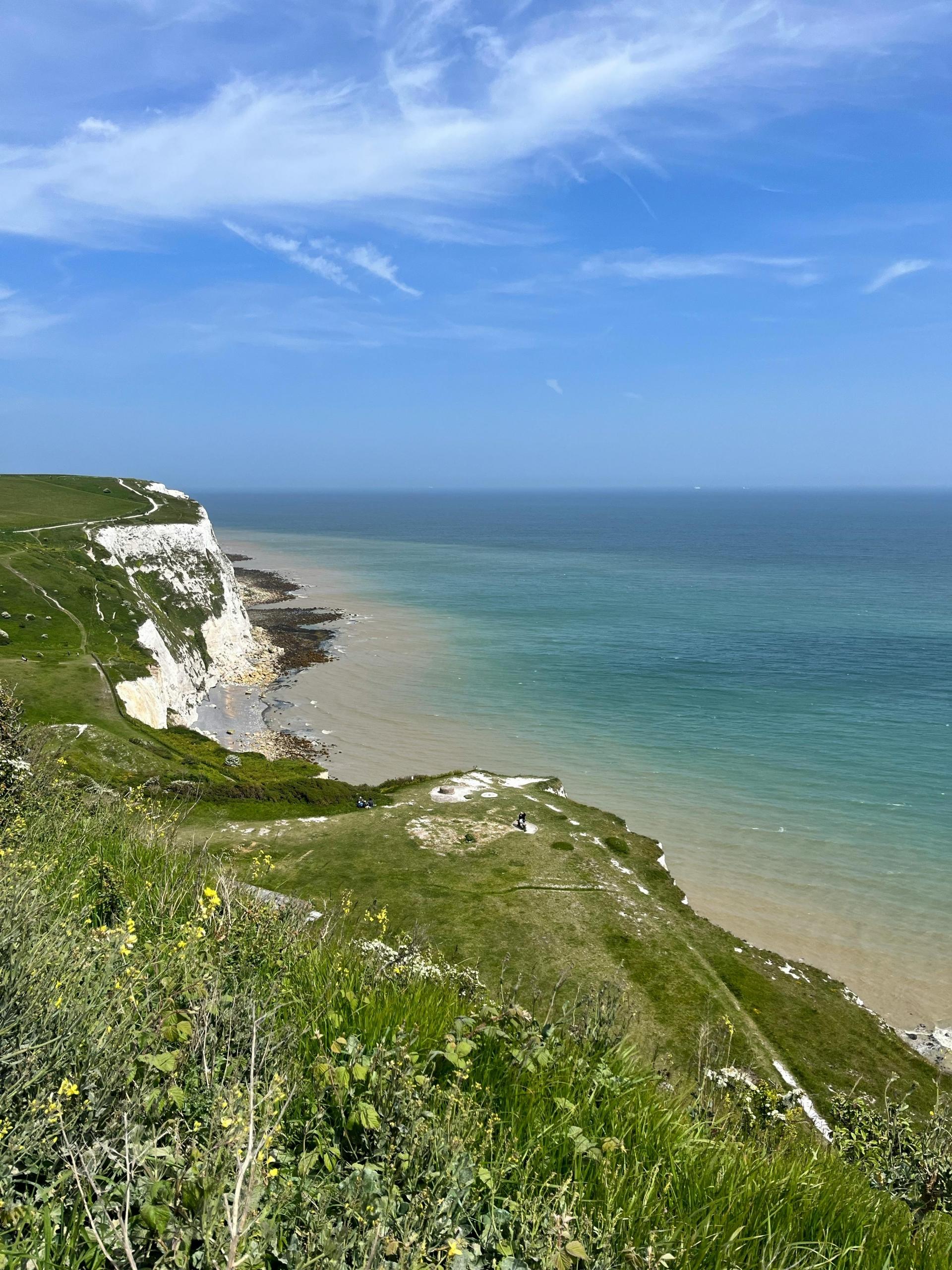
Cliff: A steep vertical formation, high rock face, especially near the sea, formed by weathering and erosion.
Stack: Formed by wave erosion, stacks are often large, vertical rock columns near the coast and cliffs.
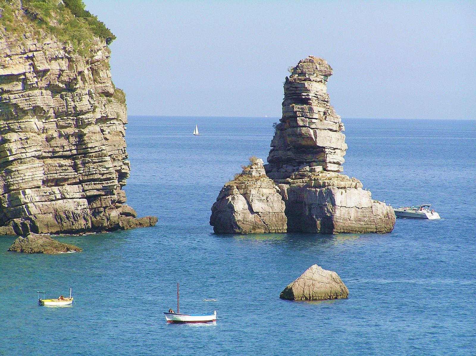
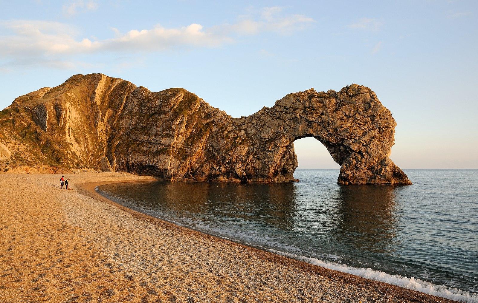
Arches: Arches form as waves crash into newly created sea caves; arches are a transitional feature formed after a cave erodes through a headland.
The water strikes the back wall and reflects, and the force of the rebounding water begins to erode the headland of the cave, eventually creating a sea arch. Over time, arches can collapse, forming stacks.
Wave-cut platform: They’re a flat surface found at the base of a cliff, formed by hydraulic action and abrasion from waves.
It forms as waves erode the base of a cliff, leading to its collapse onto the shoreline.
The platform is then shaped by wave action and may be covered with sediment, ranging from fine sand to large boulders.
Spit: A spit forms when the coastline changes direction suddenly; it forms due to longshore drift, when sediment is carried along the coast and deposited where the coastline changes direction.
It may extend into the sea or across a bay and new land is created. It is a good example of what happens when longshore drift continues beyond the end of a coastline.
How to Explain Coastal Landforms
For the GCSE in Geography, you’ll have to explain how coastal landforms are created by erosion.
Coastal landforms are the main result of the continuous interaction between land and the ocean; the relentless action of waves, ocean currents, sediments and more forms them.
Coastal Landforms are formed by erosion, a process that can also be influenced by rain through weathering.
- They form in areas with high wave energy, and rain can also contribute to the process through weathering.
- Softer rocks erode more easily, leading to the formation of bays.
- Coastlines with alternating layers of hard and soft rock give rise to headlands and bays.
- Erosion transforms headlands into features like cliffs, wave-cut platforms, arches, caves, blowholes, and stacks over time.
- Abrasion and hydraulic action—both types of erosion—can cause cliffs to retreat, leaving behind a wave-cut platform.
Is Erosion a part of the Abrasion process?
Summarise with AI:
Did you like this article? Leave a rating!


I’m interested and I am available here so I am geologist
Hi Muhammad, thanks for your comment! It’s great to hear that you’re a geologist and interested in the topic. If you’re available for tutoring or would like to share more about your expertise, feel free to create a profile on Superprof. We’d love to see your insights and experience helping others understand geography better! 😊